

Lightsource bp wants 119.4 hectares between Poundon and Marsh Gibbon for an 80MW solar farm and 80MW battery store. The council must reply by 14 September.
Lightsource bp wants to build an 80 megawatt solar farm and an 80 megawatt battery storage compound on 119.4 hectares of farmland between Poundon and Marsh Gibbon, in the far north west of the vale. The company has asked Buckinghamshire Council to fix the scope of the environmental assessment that will accompany the planning application, and the council has until Monday 14 September 2026 to answer. (Buckinghamshire Council planning register, PL/26/06440/EIASO)
The scheme is called Oakfield Grove. The request was validated on 10 August 2026, sits in the parish of Charndon and the Grendon Underwood and The Claydons ward, and was prepared for Lightsource bp by the consultancy Stantec. No planning application has been submitted yet.
What a scoping request is, and what it is not
This is not the application, and there is no formal stage at which the council collects public comments on it. A scoping opinion is the written answer a council gives under regulation 15 of the Town and Country Planning (Environmental Impact Assessment) Regulations 2017 to a developer who asks which environmental topics the eventual Environmental Statement must cover, and in how much detail. The developer then submits that statement with the planning application, and that is when neighbours, parish councils and anyone else can comment.
What the scoping report is useful for is that it is the first full public description of the scheme, written by the applicant, with the numbers in it. Everything below comes from that document unless another source is given. (Oakfield Grove EIA scoping report, August 2026)
What is proposed
The application will seek full planning permission for solar arrays on steel mounting frames, inverters, transformers, substations, access tracks, landscaping and a battery energy storage system. Once running it would have a generating capacity of 80MW of solar and 80MW of battery storage. Lightsource bp’s own project page puts that at enough to power about 30,803 homes a year and to avoid roughly 17,465 tonnes of carbon dioxide equivalent a year. (Lightsource bp, Oakfield Grove Solar and Energy Storage Project)
The battery compound would go in the middle parcel and is described as roughly 19 battery blocks of four to six units each, with each unit about 12.7 metres long, 2.6 metres wide and 3.2 metres high. Around it would be stainless steel security fencing about 2.5 metres high, CCTV columns up to 3.5 metres and lighting columns of about 3.9 metres. The solar fields themselves would be enclosed by deer netting about 2 metres high. The connection point is an underground 132kV line that already runs through the north of the middle parcel.
The company says it will ask for an operational life of 40 to 50 years, with the final figure settled at application stage, and that the batteries themselves have a design life of 15 to 20 years and would probably need replacing within the permission. At the end the site would be dismantled and returned to farmland.
Where the three parcels are
The site is three separate blocks of arable fields, labelled A, B and C, around grid reference SP649250, joined by cable routes that run along Main Street and along the lane between Poundon and Marsh Gibbon. About seven homes or businesses sit directly against the parcel boundaries. Marsh Gibbon is roughly 500 metres south of the nearest parcel and Bicester about 5 kilometres west.
Six public rights of way cross the site: bridleways CHA/1/7 and CHA/1/1 and footpaths TWY/6/1, CHA/4/1, MGI/7/1 and CHA/2/1. The Cross Bucks Way and the Bernwood Jubilee Way both pass through Poundon village on the same stretch, and National Cycle Network route 51 runs along about 260 metres of Main Street where one of the cable routes is proposed.
The site is entirely in Flood Zone 1, the lowest flood risk band, although the report notes pockets of higher surface water risk around an unnamed main river and ordinary watercourses in the southern parcel. There are no listed buildings inside it, no scheduled monuments and no conservation area, but there are about 69 listed building records within 2 kilometres, the Grade II* Church of St Mary lies about 660 metres south, and the Marsh Gibbon Conservation Area about 450 metres south. Part of the southern parcel falls inside two archaeological notification areas covering medieval to post-medieval ridge and furrow.
The farmland it would cover
This is the number most people in the villages will want. A soil survey by Amet Property, carried out in 2025 by sampling 128 points with a hand auger, graded the land as follows:
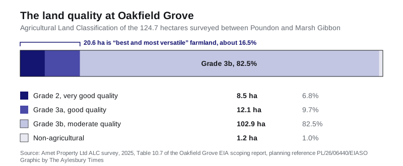
Grades 1 to 3a count as “best and most versatile” farmland in national planning policy, the category councils are expected to protect. On these figures 20.6 hectares of the site is best and most versatile, which the report puts at about 16.5 per cent, with the great majority of the land in the lower grade 3b. The limiting factor across most of the site was soil wetness, with patches of droughtiness in the centre of the northern blocks.
One thing to note if you compare documents: the survey covers 124.7 hectares and the report’s own percentages are worked out against that figure, while the site is described elsewhere in the same report as 119.4 hectares. The larger figure appears to include the cable routes.
What the assessment will and will not examine
The developer is proposing that the Environmental Statement assess only three topics in full: landscape and visual impact, traffic and transport, and biodiversity. Twelve others are put forward to be scoped out on the grounds that significant effects are unlikely, including air quality, climate change, cultural heritage, flood risk and drainage, ground conditions, agricultural land and soils, lighting, noise and vibration, materials and waste, microclimate, population and human health, and major accidents and disasters.
That list is a proposal, not a decision. Deciding which of those the council accepts is exactly what the scoping opinion due by 14 September does, and a council can require a topic back in. An EIA screening opinion was already issued in December 2025, and the company says it is undertaking the assessment voluntarily.
Lorries, lanes and 18 months of building
Construction is expected to take 18 months. On a typical day the report anticipates six to eight lorries visiting the site, which is 12 to 16 movements in and out, with a peak of 15 lorries a day, 30 movements, plus four to six vans at peak. The workforce is put at up to about 100 people a day at the busiest point.
Traffic for the two northern parcels would come off the A4421 and route through Stratton Audley and along Main Street in Poundon. Traffic for the southern parcel would come off the A41 through Grendon Underwood and Marsh Gibbon. The report says lorries are not expected to use Twyford Road, Marsh Gibbon Road or Station Road because of a 3.9 metre height limit under the OXD 32 railway bridge.
The report also argues that this particular set of lanes has been through it recently: land in the southern half of the middle parcel was used for East West Rail construction, and the passing places and widened sections put in for that work are still there, so it says the route is unlikely to need further intervention. Residents who lived through that phase may read the same fact differently. If wider disruption is your concern, we keep roadworks and travel in the Aylesbury area up to date separately.
The battery, and the risk the report scopes out
Battery storage compounds raise one question above all others locally, which is fire. The report acknowledges “some element of risk associated with BESS technology” and lists the measures intended to control it: automatic fire detection, fire resistant materials and separation between units, siting the batteries away from homes, continuous monitoring of current, voltage and temperature to shut the system down before a failure, and meeting the requirements of the fire and rescue service. A Battery Safety Management Plan would secure those measures.
On that basis the report concludes the scheme is not likely to cause significant environmental effects from major accidents, and proposes that the topic be scoped out of the assessment altogether. Whether the council agrees is one of the substantive things its September answer will settle.
Three energy and rail schemes in the same few fields
Oakfield Grove is not arriving in an empty landscape. The report’s own list of schemes to be considered cumulatively includes:
- Rosefield Solar, about 2.8 kilometres east, a solar generating station of more than 50MW on land south and west of the East Claydon substation. Because of its size it is decided nationally rather than by the council, and it is currently in examination, with the papers for deadline 6 published on 14 August 2026. (Planning Inspectorate, Rosefield Solar Farm, EN010158)
- A solar and battery site at Pool Farm, Stratton Audley, about 1 kilometre west, which already has planning permission after an appeal.
- East West Rail, part of which falls inside the middle parcel, and HS2 works about 1.5 kilometres to the north east.
- Three housing proposals at Marsh Gibbon within 700 metres of the southern parcel, the largest of them up to 90 homes off Little Marsh Road, refused in October 2025 and now under appeal.
For the wider picture of how much building the vale is being asked to absorb, see our page on what the draft Local Plan means for Aylesbury.
What happens next
The council’s scoping opinion is due by 14 September 2026. After that Lightsource bp will prepare its Environmental Statement and submit a full planning application, at which point the plans, the assessment and the consultation period all become public and comments can be made in the normal way. There is no published date for that submission.
The company held a public information event on 16 July 2026 at Charndon Community Centre, and keeps the material from it, including the proposed haul routes and landscaping for each parcel, on its project page. It gives an email address of oakfieldgrove@lightsourcebp.com and a phone number of 03332000755 for questions. (Lightsource bp project page)
What it means for you
- If you live in Poundon, Marsh Gibbon, Charndon or Twyford, nothing is decided and nothing can be objected to yet. The moment that changes is when the planning application is validated, and that is the point to watch for. The reference to search on the council’s register today is PL/26/06440/EIASO; the application will get a new one.
- If you want the scope widened, the window is now rather than later. Consultees and parish councils are the ones the council hears from at this stage, so a parish council is the practical route for anyone who thinks noise, heritage, farmland or battery safety should be assessed in full rather than scoped out.
- If you use the footpaths, six rights of way cross the site, along with the Cross Bucks Way and the Bernwood Jubilee Way through Poundon. The report proposes to keep them, but their treatment during an 18 month build is a fair question to put at application stage.
- If your concern is the lanes, the numbers to hold the developer to are 15 lorries and 30 movements on a peak day, and the stated undertaking that Twyford Road, Marsh Gibbon Road and Station Road will not be used.
- If you farm or rent land nearby, the ALC survey is a public document filed with the request, and it sets out the grade of every part of the site.
We will report the council’s scoping opinion when it is published, and the planning application when it lands.
Have your say