
Stoke Mandeville's neighbourhood plan now decides planning applications, 834 to 81 at referendum. The examiner cut its green buffer and transport policies.
Buckinghamshire Council has formally made the Stoke Mandeville Neighbourhood Plan, eleven years after the parish was designated as a neighbourhood area. The plan now sits in the statutory development plan, which means planning applications in the parish must be decided in line with it unless there is a reason not to. (Buckinghamshire Council decision, 4 September 2026)
Residents backed it heavily. At the referendum on 9 July 2026 the vote was 834 yes to 81 no, a 91% yes among those who took part. Turnout was 16% on an electorate of 5,569. (declaration of result)
What most of those voters will not have followed is how much of the plan had already gone.
The green buffer did not survive
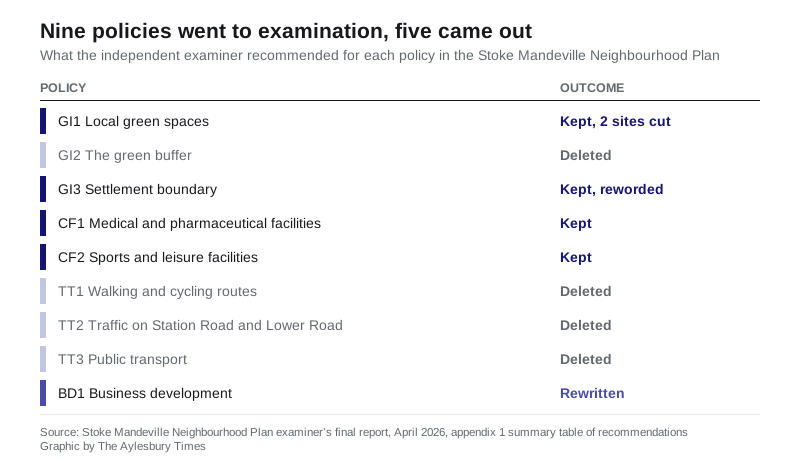
The parish submitted nine policies. Five are in the plan that has just been made.
The one people fought hardest for was GI2, the green buffer. It would have required a strip of green space between the existing village and the housing coming forward on AGT-1, the large allocation between the northern edge of the village and the line of the South East Aylesbury Link Road.
The independent examiner accepted that “there is considerable support for the NP’s version of the green buffer from local residents”. He deleted it anyway. (examiner’s final report, April 2026)
His reasoning was that a buffer is already required by the adopted Vale of Aylesbury Local Plan and mapped in the council’s supplementary planning document for AGT-1. The parish drew it in a different place. Substituting one line for another, he wrote, “would simply replace certainty with uncertainty”.
Buckinghamshire Council objected to the policy. So did agents for Juniper Investments Ltd, Arrow Planning acting for a consortium promoting the development of AGT-1, and agents for a local farmer.
The parish council’s case, quoted in the report, was that the buffer “is the only way we can try and protect the interests of our residents and mitigate how they will be impacted by having new developments where before they enjoyed rural views and a measure of isolation from other houses”. The examiner replied that the parish’s version was, at least in part, motivated by a desire to protect private views of countryside.
All three transport policies went too. They covered walking and cycling routes, traffic on Station Road and Lower Road, and bus provision in new developments. The examiner found they either duplicated the Local Plan or, in the case of traffic management, were not land use planning matters at all.
What the plan does now protect
The five surviving policies are worth knowing, because they are what a case officer has to weigh.
- GI1 designates 15 local green spaces. National policy treats these like Green Belt: development on them is harmful by definition and should be refused except in very special circumstances. They include grassland at Rowan Close, Barley Crescent, Ravensbourne Road and Harvest Close in Hawkslade, the QE2 recreation ground on Eskdale Road, the village green on Lower Road, and the burial ground and allotments off Lower Road.
- GI3 draws a settlement boundary. Development inside it is supported in principle. Outside it, proposals are judged against the countryside policies of the Vale of Aylesbury Local Plan. The AGT-1 allocation and part of AGT-2 sit inside the boundary, because they are already allocated.
- CF1 supports new medical capacity. The plan records that there is no GP surgery, dentist or pharmacy anywhere in the parish.
- CF2 supports new sports and leisure facilities, and singles out formal pitches with changing rooms for cricket, football, hockey, netball and tennis.
- BD1, in wording written by the examiner, supports new or expanded businesses and gives “particular encouragement” to new shops, cafes and restaurants.
(Stoke Mandeville Neighbourhood Plan, referendum version)
The playing fields the plan does not protect
The parish put forward 17 local green spaces. Two were removed.
The significant one is LGS5, the former Buckinghamshire County Council sports and social club playing fields. The council owns the land. In August 2024 it granted outline permission for up to 100 homes there. The parish council took that decision to judicial review and the High Court quashed it in May 2025 on procedural grounds, according to the examiner’s account of the site’s history.
The examiner still recommended the land be left out. He found the larger northern parcel almost impossible to see from the public realm, and no evidence that the land is special in the eyes of the community. He also recorded that the council, as both landowner and planning authority, is working with the parish on options for the site and could give no timescale.
The other deletion, LGS15, was a narrow strip said to give access from Irvine Drive to the recreation ground. The examiner could not find any evidence on the ground that the access existed.
Eleven years, two examiners
The parish was designated a neighbourhood area on 8 July 2015. A second version of the plan went to examination in 2024, and the plan itself records that the first examiner “made a number of errors in his references and subsequent recommendations”. It was agreed with Buckinghamshire Council that the plan be amended and sent to a second examination under a different examiner.
The area the plan covers changed enormously while it was being written. It now takes in three completed estates and two planned neighbourhoods on top of the original four, an addition of more than 2,800 homes. HS2, the Stoke Mandeville Bypass and both Aylesbury link roads run through the parish.
The plan is candid about the limits of what it can do. It states that the neighbourhood plan “is powerless to prevent development where land has been allocated in the strategic plan for housing and infrastructure”.
What it means for you
If you live in the parish, the plan is live now and you can cite it.
- Objecting to an application? Quote the policy number. A case officer has to address conflict with GI1, GI3, CF1, CF2 or BD1 in the report. Our Aylesbury planning news page follows what is in the system.
- Worried about a green space near you? Check whether it is one of the 15 designated in GI1. If it is, the bar for building on it is now very high. If it is not, the plan gives it no extra protection.
- Expecting a green gap north of the village? The requirement still exists, but it comes from the Local Plan and the council’s AGT-1 supplementary planning document, not from the neighbourhood plan. The parish’s own version of where it should go has gone.
- The plan runs to 2033. The parish council can review it, but any review means another round of consultation and examination.
There is a six week window from the day the plan was made in which the making of the plan can be challenged in court.
The made plan, the examiner’s report and the decision are all on the council’s neighbourhood plans page.
Have your say